
Laurel Falls Trail is one of the most well known hiking trails in the national park, and it leads to the beautiful 80-foot titular falls that are on many visitors’ must-see lists. This is a fairly easy trail – possibly the easiest one leading to a great waterfall. It’s a paved path that features relatively small elevation changes, so it’s a good choice for families or inexperienced hikers.
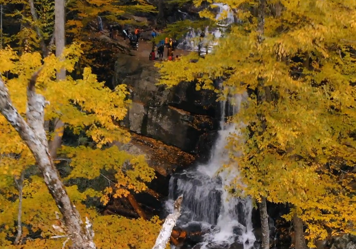
Image courtesy of smokymountains.com
Explore one of the most popular trails in the Smokies
The trail leading to Laurel Falls draws scores of park visitors every year, and it’s easy to see why. Even before you get to the end of the trail and actually see the waterfall, you’ll find plenty of natural beauty along the path and get to experience some of the classic flora of the Smokies. This includes the mountain laurel for which the trail is named, which is usually in bloom in May, but there is plenty of other vibrant plant life to be seen throughout the trail. There are many good spots for photos along the path, and mornings and afternoons typically produce some fantastic light coming through the trees that can help set you up for the perfect shot.
Laurel Falls and the trail are very popular, which means you may have to deal with some crowds during the peak times – it can get VERY crowded and with people who are not well versed in nature etiquette or the rules of the park. Your best bet for avoiding the heaviest traffic is to complete the hike earlier in the morning if possible and then move on to other attractions that don’t get quite as many visitors.
Enjoy a pleasant hike with the whole family
Aside from its beauty, one of the main reasons why the Laurel Falls trail is so popular is because it’s a relatively easy hike that can be completed by just about everyone regardless of skill level. The trail runs 1.3 miles each way (so the round trip is 2.6 miles), but there is only 314 feet of elevation rise, so it’s a fairly easy-to-moderate hike even though it provides some challenge. The trail is paved but the surface is also broken and uneven, so wear appropriate hiking footwear – and this is not a suitable path for strollers and certainly not wheelchairs. It’s a great trail for kids, just make sure that they stay on the paved path because there are some steep areas if you venture off that could be dangerous. This is bear country so please follow the proper procedures for wildlife in the park.
See the beauty of Laurel Falls up close
Once you’ve completed the 1.3-mile journey you come face-to-face with Laurel Falls itself, an 80-foot waterfall flowing down mountain rock that is well worth the journey. The trail continues past the falls and is worth exploring a few more hundred feet to reach the top of the falls for a magnificent view. As long as you’re not looking for a deserted trail that makes you feel like you’re alone in the deep wilderness, you’ll find the journey and the destination very rewarding. Additionally, the drive to the trailhead takes you down Little River Road, which is another spot filled with some scenic treasures of its own. From Sugarlands Visitor Center, the trailhead parking area is approximately 3.5 miles along this road.
The Laurel Falls hike round trip need take no more than a couple of hours, and it’s in a very accessible location within the national park, which makes it easy to pair this brisk hike with another activity. The trail itself extends to other places if you’re a hiker, or returning to your car puts you back close to Gatlinburg, or back on the road towards Cades Cove.
TIP: Also see our Insider’s Visual Guide to the National Park – and with an abundance of different cabins close to the park to choose from, check out our tips on How to Find an Affordable Gatlinburg Cabin, How to Find a Gatlinburg Cabin With Spectacular Views and How to Find a Secluded Gatlinburg Cabin.